Making the Invisible Visible.
Making the Invisible Visible.
Civilian Airspace Monitoring in Real Time. Completely Passive. License-Free Operation. Made in the EU. Ideal for Critical Infrastructure.
Civilian Airspace Monitoring in Real Time. Completely Passive. License-Free Operation. Made in the EU. Ideal for Critical Infrastructure.
The Threat from Above Is Growing
Drones and other airborne objects are increasingly posing a risk to sensitive infrastructure. They often go undetected—until it’s too late.
Our system provides visual clarity in an area that has so far remained blind.
How Airspace Monitoring Works
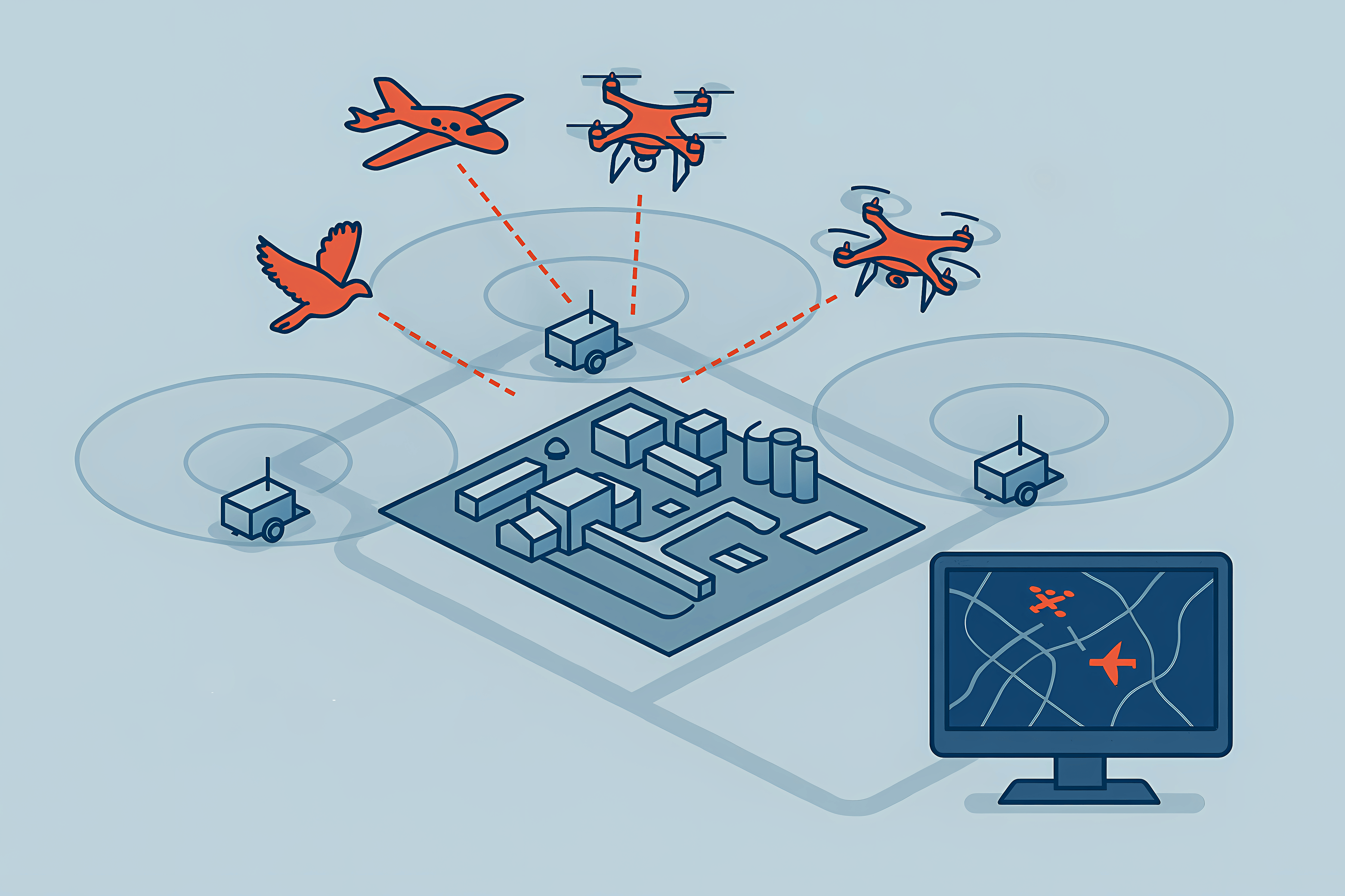
Drones (emitting / non-emitting)
Light aircrafts / helicopters
Birds / other objects
Interference signals & jamming

Flying objects
Detection, classification, and identification of drones, helicopters, airplanes, and other aerial objects.
Multi-sensor system
The mobile ground-based multi-sensor system can be mounted in a trailer or installed permanently with an antenna mast. Three sensors reliably monitor areas such as industrial facilities or airports.
Unified management interface
Airspace situation display shows drone positions for incident events. Browser-based and accessible via mobile devices.
Three mobile sensor units are strategically positioned around the area to be monitored. Without emitting any signals themselves, they detect everything moving in the airspace – whether it’s a radio-controlled drone, a glider, or a flock of birds. Data from radio, radar, and telemetry sources is merged in real time, providing a comprehensive and seamless overview – reliable, discreet, and operable without a license.
The advantages of such combined technology go beyond mere threat prevention. Precise detection enables the collection of evidence and detailed analysis after an incident. This is of significant importance for clarifying causes (such as in the case of an unexplained crash) or for insurance matters.
Furthermore, the system provides substantial organizational value for the event organizer: Authorized drones, for example from media partners or emergency services, can be automatically recognized by the system and assigned to the responsible parties. This simplifies the coordination of approved air traffic and allows for quicker differentiation between authorized flight movements and potential threats.
Integrated solution for GNSS monitoring and drone detection
The security company hensec is currently the only provider offering a comprehensive and integrated solution combining GNSS quality monitoring (spoofing and jamming detection) with advanced drone detection, including the recognition of non-cooperative drones. Conventional GPS jamming detection systems merely identify that a signal is unreliable but cannot distinguish whether the issue is interference, jamming, or spoofing. In other words, they detect that something is wrong, but not what exactly. The hensec solution, however, provides an extensive analysis of GNSS signal quality in multiple aspects, allowing even sophisticated spoofing attacks to be detected and immediately countered, for example by blocking manipulated radio signals.
The GNSS components already comply with the latest EU guidelines.
Our sensor technology in combination
Our system combines leading technologies from various fields of passive airspace surveillance — developed and operated by experienced European specialists.
Together, this creates a unique, civilian all-in-one solution for critical infrastructures – modular, scalable, and fully "Made in the EU."
Radio detection (hensec / aaronia)
Detects radio-controlled drones and transmitters precisely in real time.
Passive radar (parasol)
Detects non-transmitting objects based on reflections of existing signals.
Radiotelemetry (airsenso / avionix)
Uses flight telemetry data for precise localization.
GNSS Jamming Detection (GPSPatron)
Detects GPS interference and spoofing attempts.
Everything on one screen
All sources merge into a clear situational picture — centralized on a single screen.
Why this system?
-
Completely passive
no active transmission, no licensing required -
Made in EU
Data protection compliant, secure & sovereign -
Modular & scalable
ideal for temporary or permanent protection -
Unique
first all-in-one solution for the civilian sector
Use cases

Airports

Industrial plants

Tank storage facilities

Test sites

Offshore wind farms

Large-scale events

Major incidents

City centres
Whether at the airport, in the chemical plant, at the harbor, or on a test site — wherever airspace security is essential, our system provides transparency. Scalable and quickly deployable — all without bureaucratic hassle.
Request information now
Or contact us by phone or email to request a consultation or additional documents:


